
Trace a Fairfield Street from Address to Name
A Fairfield street search starts with the exact address but should quickly gain a parcel key. Vision can return a card with an owner, mailing field, Mblu or map-lot reference, account, PID, legal description, and sale history. The CT Metro GIS Viewer II can then show the parcel and nearby layers. SearchIQS works from parties, dates, instruments, and legal descriptions. The voter lookup and historical directories add different kinds of household context.
- Enter the full address in Vision and copy the card date, owner, map or lot, account, PID, and legal description.
- Open the CT Metro parcel viewer, identify the parcel, and note adjacent parcel IDs and street-layer labels.
- Use the state voter lookup only for registration or polling context, respecting its protected-address warning.
- Search SearchIQS by current or prior party, date, document type, book or page, and instrument number.
- Ask the Museum or Library for a dated directory, obituary, or property-file lead when the question reaches backward.
The Fairfield path is address to parcel, parcel to legal description, legal description to recorded parties, and date to household context. A name appears only after the Fairfield source role is clear.
Fairfield Records Searchable by Address
Several Fairfield record sets can be reached from a street address, but each has a different custodian and limit. Vision is the fiscal card. Fairfield GIS is a mapped information layer. SearchIQS is a land-record index. SOTS and the Registrars handle voter registration. The Building Department owns permit files, while USPS tests deliverability. A Fairfield street directory search is strongest when the same parcel key or date links two sources.
| Record set | Keeper | Street-level value | Access |
|---|---|---|---|
| Fairfield Vision property card | Fairfield Assessor | Owner, mailing, parcel, assessment, sales | Online card; Old Town Hall and 203-256-3110 |
| Fairfield GIS parcel layers | Engineering and CT Metro | Address, street, parcel, zoning, flood, historic layers | Viewer and REST service; informational only |
| Fairfield land records | Fairfield Town Clerk | Parties, instruments, book/page, legal description | SearchIQS or counter; 203-256-3090 |
| Fairfield voter context | SOTS and Registrars | Registration, party, polling, district clues | Lookup and local office; suppression applies |
| Fairfield permit records | Building Department | Address-linked applications and project leads | Counter, City Squared, or FOI; live search unverified |
| Fairfield postal match | USPS | Recognized city and ZIP for an exact address | Online lookup; not occupancy proof |
These records can be compared, not collapsed. An assessed owner may have a distant mailing address. A deed party may be an organization or prior owner. A voter result can be suppressed. A GIS polygon can be stale. Keep the Fairfield source and date beside every street-level claim.
Fairfield Street-Address Vision Search Fields
The Vision prompt is unusually useful because it accepts more than a typed street address. A known owner, Mblu, account, or PID can recover a Fairfield parcel when the street number is old, misspelled, or hard to read. The Fairfield Tax Assessor page supplies the office and Grand List context behind that card. Fairfield’s displayed data uses the final 2025 Grand List, and the field-card pages are updated annually. Exemptions are excluded from the displayed assessment results.
| Field label | Portal prompt | Address workflow |
|---|---|---|
| Fairfield address | Address text | Find the current situs candidate |
| Fairfield owner name | Name text | Test an assessed owner or prior spelling |
| Fairfield Mblu | Map-block-lot-unit key | Hold the parcel identity across systems |
| Fairfield Acct# | Account number | Return to the fiscal card |
| Fairfield PID | Property ID | Match the map and data references |
The direct live controls for sorting, pagination, and exports were not exposed in the Fairfield capture, so those functions should not be assumed. Copy the printed Grand List year and card date before comparing an owner with a deed.
- Parcel
- A mapped property unit tracked by Fairfield identifiers such as an Mblu, account, PID, map and lot, or GIS number.
- Situs address
- The physical address assigned to the parcel. It is different from a mailing address used for assessment notices.
- Plat
- A recorded or mapped plan that shows lots, streets, and other land relationships. It helps explain a legal description, but it is not a survey by itself.
- Criss-cross directory
- An address- or street-ordered directory that can point from a known location to a listed name. Fairfield-specific coverage was not verified, so ask the Museum before assuming a run exists.
These terms keep the Fairfield street directory workflow precise. An address helps find a candidate, a parcel key ties the candidate to the assessor and GIS, a plat or legal description gives the land context, and a criss-cross entry, if one is available, supplies a dated household clue. None of those steps turns a mailing field or directory line into proof of present occupancy.
For an older Fairfield street, write the current address beside every historical spelling and source date. Then test the parcel identity before comparing a directory line with a deed or a voter record. That small record of terms prevents a map label, tax account, and household name from being treated as interchangeable evidence.
Fairfield GIS Street and Parcel Layers
Fairfield GIS and the CT Metro Fairfield parcel service can add context around an address. The documented layers include address number, parcel label, parcel geometry, street name, land use, easements, utilities, flood areas, historic districts, zoning, roads, soils, town boundaries, and aerial basemaps from 1934, 1965, 1968, 2013, 2016, 2019, 2020, and 2024. Identify, Query, and Export operations are documented, while a radius search was not located.
The Fairfield CT Metro parcel service provides the Fairfield layer metadata represented below.
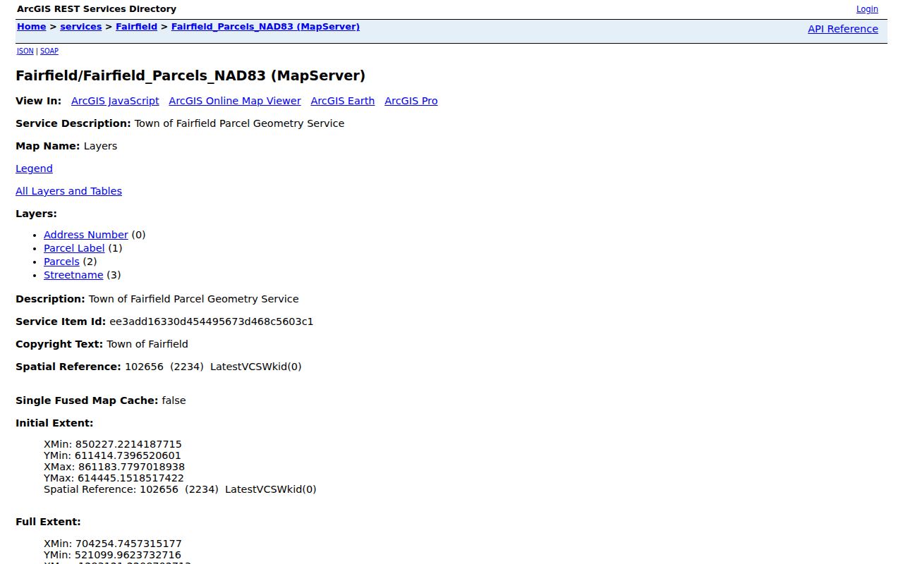
GIS makes a Fairfield adjacent-parcel workflow possible: identify the target polygon, click nearby parcels, and carry each parcel ID back to Vision. The Fairfield map is informational, not a title source, legal survey, or proof of a current address.
When a Fairfield street runs through a historic district, flood layer, utility corridor, or easement, preserve the layer name and date. A colored Fairfield map feature is a clue to the relevant office, not a final legal finding.
Fairfield Street Deeds and Recorded Instruments
SearchIQS warns that not all municipalities index land records by address. Begin with the Fairfield Vision legal description, map or lot, and owner, then search Party 1 and Party 2, date From and Thru, document group or description, town, book and page, instrument number, or case number. A wildcard can help with a name variant. Results may show View, an image marker, View Selected, Names Summary, and My Documents.
Current help lists Fairfield land-record index data and images from January 3, 1977 onward, earlier grantor and grantee index books, and record-book images for an older range. An older PDF conflicts with some boundaries. Guest searches are free, while image, download, and print access can require an account or payment. The Fairfield Town Clerk at 611 Old Post Road is the fallback for older books, certifications, and missing images.
Read each Fairfield instrument by role. A Fairfield deed, mortgage, release, easement, probate filing, or tax lien does not carry the same meaning, and a grantor or grantee is not automatically a household member.
Fairfield Permits by Address
Fairfield’s Building Department is at Sullivan Independence Hall, 725 Old Post Road, second floor, with counter hours from 8:30 to 10:30 AM and 3:30 to 4:30 PM. Office hours are 8:30 AM to 4:30 PM, and the phone is 203-256-3036. Existing permit or project records should be requested from the department when a public search result is not available.
City Squared began Fairfield online permitting on March 1, 2022 for Plan and Zoning, Conservation, Building, Engineering, and Sewer applications. The municipal page says payment requests are emailed after review. A live public address search was not verified, so a Fairfield address, permit date, project type, and parcel key should be included in a counter or FOI request.
Permit history is Fairfield municipal activity at a Fairfield address. It can help explain an addition, review, or project, but it does not establish who occupied the parcel.
Fairfield Place Names and Address History
Street research in Fairfield needs three address keys: the contemporary situs, the parcel identity, and the historical place or street wording. Southport, Greens Farms, Greenfield Hill, Stratfield, Fairfield Beach, and Mill Plain can appear in directories, maps, newspapers, postal material, or civic lists without being legal town subdivisions. Fairfield’s original territory also included land later associated with Easton, Weston, Redding, Westport, and part of Bridgeport.
When a Fairfield address changes, compare the deed legal description, assessor card and prior card, GIS parcel ID, directory year, USPS result, permit or tax date, and a Fairfield town or neighborhood source. If the parcel ID stays stable while the number changes, preserve the former number as historical. If a parcel splits or merges, retain the old lot references rather than forcing every record into a current street label.
Fairfield Street ZIP and Postal City Checks
USPS has separate modes for a full address, city and state, and cities by ZIP. The full-address route uses street, optional unit, city, state, and ZIP fields. A result confirms postal routing, not ownership, occupancy, or a legal municipal boundary. Unit information can narrow a multi-match, and the recognized city should be copied exactly for Fairfield research.
Official Fairfield research uses 06824, 06825, 06828, and 06890 in different contexts. A 2002 Postal Bulletin created the 06890 Green Farms and Southport delivery area, while a 2006 notice documents routing changes involving 06824, 06825, and 06828. Use the Fairfield USPS address lookup, then keep its postal city separate from the legal town and the parcel’s situs.
Fairfield Street Directory Lines and Neighborhood Clues
The Fairfield Museum research library holds local directories from 1855 through 1979, house and property files, atlases, tax references, surveys, and photographs. The Fairfield Public Library adds obituary and newspaper indexes. A regional directory may list Fairfield under Bridgeport, Southport, or a neighborhood term. A dated line can show a person at a street address for that publication year, not present ownership or residence.
Neighborhood names can refine a Fairfield search. The town’s official association inventory includes Fairfield Beach Peninsula, Greenfield Hill Village Improvement Society, Lake Hills, Mill River-Brookside, Sasquanaug Conservancy for Southport, Stratfield Village, and other civic groups. The contact list is not a member roster. When the task shifts from a whole street to one older household, the Fairfield city directory collections provide the fuller historical shelf.
What a Fairfield Street Directory Cannot Show
A Fairfield street directory cannot promise a complete list of current occupants. A parcel card may omit household members. A mailing address may be distant from the situs. A voter address may be protected. A directory may be years old. DMV personal data is restricted, and no public utility customer roll was located. The court property search is a case locator, not a current-occupant search.
Lawful use. Fairfield address records support personal, civic, family-history, and property research. Respect voter suppression and Safe at Home protections. Do not use a public source to stalk, harass, intimidate, or harm anyone, and verify a person or parcel claim with the Fairfield custodian.
When Fairfield records disagree, preserve the dates and roles instead of picking the most convenient name. The Fairfield Town Clerk, Fairfield Assessor, Registrars, Building Department, GIS staff, or Library can explain the record that each office actually owns.